|
Family Cycling
|
Cornwall |
|
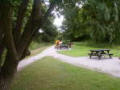
The
Camel Trail
The Camel Trail winds through some of Cornwall's most
beautiful and little known countryside. There are many
visitors to the Trail each year; some use it daily for
jogging or bird watching, others for an occasional day
out walking or cycling.
Being on an old railway track the Trail is virtually
level all the way. The surface is mainly smooth and so
ideal for wheelchair users, pram and buggy pushers. |
|
Pentewan Valley Trail
Pentewan near Mevagissey.
A shorter version of the Camel Trail, traffic free and
level, hence particularly suitable for families. Nearly
3 miles long, past the sluice ponds, through ancient oak
woodland and alongside the River. Car parking at both
ends. Cycle hire available. Pentewan used to be an
important Port. Though the Harbour entrance is now
blocked by sand, the Harbour Basin with its wooden
sluice gates, like the sleepy village itself is a
delight to explore. The beach is broad and sandy,
popular with sailors, home to a thriving local sailing
club. From the end of the Trail Heligan Gardens is only
a short cycle ride away. Happily (some may say) the
Pentewan Trail is far less popular than Camel Trail.
|
|
Derbyshire |
|
Longdendale Trail
The Longdendale Trail runs for around 6.5 miles, from
just beyond Hadfield Station to the entrance to the
Woodhead Tunnel. Following the Trans-Pennine railway
closed in 1981.
This is an excellent trail, especially for families and
beginners. The surface is of smooth sand, which can make
the going quite difficult when it is wet. This is not
really a trail to try in bad weather, as it is very open
to the elements. It is advisable therefore to choose
your direction of travel according to the wind
direction.
|
|
Sett Valley Trail
The Sett Valley Trail runs 2.5 miles. It runs from
Hayfield Station to New Mills.
The Sett Valley Trail is at first hard work with many
gates and obstructions to negotiate. However, from
Hayfield onwards it is quite very pleasant. Hayfield
village is well worth a visit and if you want to see
some of the unspoilt countryside, then walk from the car
park near Bowden Bridge towards Kinderlow Edge past
Tunstead Clough Farm.
|
|
Middlewood Way
The Middlewood Way runs for a total of 11 miles, from
Marple to Macclesfield.
The Middlewood Way is provides the ideal opportunity for
a quiet and enjoyable family outing. Picnic sites are
situated at various points along the trail. The
Middlewood Way also offers walkers a number of
alternative routes and circular walks via the nearby
Macclesfield Canal and Ladybrook Valley.
|
|
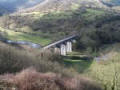
Monsal Trail
The Monsal Trail runs for 8.5 miles between Blackwell
and Monsal Head
The Monsal Trail follows the deep limestone valley of
the River Wye with crags towering 100 metres above, a
river that changes from a fast flowing torrent to a
serene lakeland paradise, and spanned by the Monsal
Viaduct. This trail is among the very best that you'll
find in the Peak National Park.
|
|
High Peak Trail
The High Peak Trail joins up with the Tissington Trail
at Parsley Hay. It is 17.5 miles long and follows the
old Cromford Railway, starting at Cromford and finishing
at Dowlow, south of Buxton.
This is perhaps the most interesting of the trails
because this old railway line is much less straight than
other railways, with sharp curves which seem to give
frequent changes of view. For a railway line it is, in
fact, not level and has several fairly steep inclines,
which now provide variety for the cyclist.
N.B. The steep inclines may seem fun, however cyclists
are not advised to ride on them. |
|
Tissington Trail
Together with The High Peak Trail, this is the oldest of
the Peak District Trails. It runs 13 miles from what was
Ashbourne Station to join The High Peak Trail at Parsley
Hay.
This is a very pleasant ride, the surface is limestone
so will be good in all weathers. The northern half runs
over the limestone uplands, the remainder being the
through softer lines of the lower valleys where the
trail is largely wooded, giving occasional glimpses of
the landscape. This trail is uphill all the way North,
so it is a good idea to head North first.
|
|
Manifold Track
The Manifold Track, located entirely within
Staffordshire, runs for a total of 9 miles. It meanders
through two river valleys; the Manifold and the Hamps.
The section of the Manifold Valley through which this
track runs is quite a good example of the deep limestone
valleys of the White Peak. It is quite wooded so the
views are not as spectacular as other trails. The most
notable feature is Thor's Cave.
N.B. The section between Wettonmill and Swainsley is
open to vehicles, so you will need to keep close to
children
. |
|
Devon |
|
Devon
Tarka Trail
Thirty two miles of the Tarka Trail are a cycle/walkway,
following the old railway line from Braunton on the
north Devon coast, to Petrockstow deep in the heart of
Tarka Country. This part of the Trail offers easy, flat,
traffic-free cycling suitable for all the family around
the wide expanse of the Taw/Torridge Estuary, before
following the River Torridge inland.
|
|
Kent |
|
The Crab and Winkle Line
A 12 kilometre off-road link
between Canterbury and Whitstable, along parts of the
now disused Crab and Winkle railway line, the first
passenger line to be opened in the world.
Canterbury to Fordwich
A short route of only 2.6
kilometres, it is a pleasant and safe route for all the
family. Following the Stour River with places to picnic,
a lovely pond and two great pubs at Fordwich.
The Escape Route
CLICK HERE
Bewl Water -
A 21 kilometre off-road route
around Bewl Water Reservoir.
For details
CLICK HERE
Tel: 01892 890661
Thames-Medway Canal
7 kilometres of very flat
cycle route through the North Kent Marshes from Higham
to Gravesend. There is a bridleway detour to Shornemead
Napoleonic Fort.
Bedgebury Forest
There are a number of cycle
routes through the Forest. Information is available on
arrival at the forest centre. For more information on
cycling around Tunbridge Wells and Bedgebury Forest, why
not buy one of our the Parish Pedals packs.
Dover to Folkestone and Hythe
Using National Cycle Route 2,
this route follows the top of the White Cliffs, with
fantastic views along the coastline. From the centre of
Folkestone, the route is almost totally off-road for a
further 10 kilometres to the Royal Military Canal.
Riverside Country Park
Cycling from Otterham Quay to
the Strand at Gillingham, this 7 kilometre route follows
the coastline through the North Kent Marshes area,
famous for its bird life.
Trosley Country Park
This park covers 160 acres of
the North Downs near Meopham. Cyclists are permitted to
use the main routes through the woodland, if they are
prepared to travel slowly and give way to pedestrians.
Mountain bikers and other cyclists looking for more
adventurous routes should use the bridleway around the
perimeter of the park.
Shorne Wood Country Park
This 174 acre park is situated
near Cobham, off the A2. There is a safe cycling and
horse riding route around the park.
Bluewater
There are 4 kilometres of
cycle routes around Bluewater shopping complex, passing
peaceful lakes and picnic spots. Bike hire is available
at Bluewater and there are cycle racks, lockers and a
centre specifically designed for cyclists to lock bikes
and take a shower before going shopping. Bluewater is
linked to National Cycle Network Route 1.
Samphire Hoe
This new piece of Britain was
created from the material dug during the building of the
Channel Tunnel. It is situated just off National Cycle
Route 2 of the National Cycle Network, between Dover and
Folkestone. If you have to travel by car, it is just off
the A20. There are three kilometres of cycle routes,
some beautiful scenery, interesting wildlife and a small
café and toilets.
Penshurst Off-Road Centre (PORC)
This fantastic facility is
open all year in Viceroys Wood. There are a number of
off-road routes for all levels of ability, from very
technical to some great leisure routes. Cycles can also
be hired on site. Contact PORC on 01892 870136.
Sittingbourne to Conyer Creek
A beautifully quiet route
running for 3 kilometres from Sittingbourne Stadium
along the spectacular North Kent Marshes to the
delightful village of Conyer.
Faversham to Graveney
A delightful section of
National Cycle Route 1, along Faversham Creek to the
hamlet of Graveney. The route continues on quiet country
lanes to Seasalter and Whitstable. From there you can
cycle the 12 kilometre section of National Cycle Route 1
along the Crab and Winkle Way, to Canterbury. There are
regular trains back to Faversham from Canterbury.
|
|
Lancashire |
|
Tandle Hill to Hollins.
17km (11 miles)
90% car free
Its a medium ride no major hills and almost all well
surfaced.
Best on a mountainBike or Hybrid as it does have a
high propertion of off road riding.
It is suitable for beginners and children.
Entrance to the car park at Tandle Hill country
park, Royton Oldham is on the A671 Between Oldham
and Rochdale.
Stations close by are:Oldham 4km and Rochdale 3km
and shaw & compton 2.5km.
There is a cafe at the vistors centre, open most
weekends and 1 pub enroute.
Great views from Tandle Hill, The Rochdale canal and
good paths all around Hopwood Hall.
This route forms a figure of 8, the paths are good
and the views are brilliant.
While the loops north of hollins includes really
good tracks.the two tracks are connected by a short
stretch on the towpath of the rochdale canal.
Tandle hill is one of Oldhams oldest country parks
with 110 acres of woodland and grass land, great
views toward the pennines and the east.
Submitted By DaisyBev
|
|
Lancaster – Morecambe
3 miles
Starting from the city's
Millennium Bridge, the cycle path is a direct route
to the seaside resort of Morecambe. |
|
Lancaster – Caton
5 miles
From the Millennium Bridge, head out to the Lune
Valley along this riverside cycle path. There are
stunning view from the Crook O' Lune |
|
Lancaster – Glasson
5 miles
Ride down the Lune Estuary to the historic dock at
Glasson, where you can see boats unloading |
|
Lancaster – Snatchems
2 miles
Cycle along the north side of the river to
Snatchems, where the press gang operated. |
|
Lancaster Canal (Lancaster – Carnforth
6 miles
You can cycle along the way as the canal from
Lancaster to Carnforth. Bring some bread to feed the
ducks. |
|
Blackpool
North Shore Cycle Route
4 miles
Cycle down the Prom from Cleveleys to North Pier in
the heart of Blackpool |
|
Stanley Park – Staining
2 miles
Combine a visit to the zoo with a cycle ride from
Stanley Park to the nearby village of Staining on an
off road path |
|
Wyre
Wyre Estuary Country Park
1½ miles
Cycle alongside the Wyre
Estuary from Stannah. |
|
Ribble Valley
Dunsop Bridge
2 miles
The bridleway up the valley from Dunsop Bridge is
tarmac and a good place to take kids. |
|
Old Tramway Cycle Route Preston – Bamber Bridge
3 miles
Following an old tramway, this route links Avenham
Park on the banks of the River Ribble with Bamber
Bridge |
|
River Ribble Cycle
Path 3 miles
You can cycle alongside the River Ribble from The
Tickled Trout by the motorway junction to Penwortham
Bridge, past riverside meadows, woods and parks.
Take care when crossing the busy London Road |
|
Chorley Area
Cuerden Valley Park, Chorley
3 miles
You can cycle for three miles through this
attractive park, north of Chorley. |
|
Astley Park
1 mile
Cycle through the park to historic Astley Hall. Look
at the hens and ducks on the way. |
|
Rivington Country Park
2 miles plus
Cycle down to the lake for a short ride. Longer
rides can also be made in the park. |
|
West Lancashire
Cheshire Lines
4 miles
Following an old railway this path takes you from
Ainsdale, near Southport to Lydiate, through the
West Lancashire countryside. It links with the cycle
path on the front at Southport |
|
Hyndburn
Woodnook Greenway Accrington – Baxenden
2½ miles
A delightful path along an
old railway through a wooded valley. |
|
Burnley
Padiham – Ightenhill
2 miles
A delightful route along the peaceful Calder Valley
to Ightenhill Bridge. There is a steep path up from
the bridge to Ightenhill. |
|
Pendle
Canal Towpath
7 miles
Take the kids on the canal towpath. You can cycle
all the way from Burnley to Barnoldswick and there
are places to stop on the way.
|
( Back To Top )
|
Leicestershire |
|
Cycle
Trails
Foxton Locks Trail - Leicestershire
Grand
Union Canal
This route gently winds its way through rural
South Leicestershire along a section of the
Grand Union Canal towpath that was built in 1809
as part of the original Grand Junction Canal.
It starts in the lovely old town of Market
Harborough and passes through some of
Leicestershire's most attractive countryside
Highlights along the way are the picturesque,
and fascinating Foxton Locks and Inclined Plane.
Vital Statistics and details
* Surface - all weather
* Distance - 6 miles (8km)
* Difficulty Level - moderate
* 100% (canal towpath)
* Parking - Foxton Locks Country Park, Gumley
Road (£1 charge), Union Wharf, Market Harborough
* Public Toilets - Foxton Locks Country Park Car
Park, Union Wharf
* Refreshments - café, Foxton Locks, Union Inn
Hotel, nr Union Wharf, various shops, cafes and
pubs in Market Haborough
* Other Routes to Try - Market Harborough Round,
Brampton Valley Way, Grand Union Canal to
Leicester
British Waterways have opened many towpaths
throughout the country for cycling. For more
information go to
www.waterscape.com
Submitted by Patch666
|
|
Lincolnshire
|
|
North East Lincolnshire
Humberston to Cleethorpes Pier
2 1/4 miles
This path is ideal for
young children to cycle on with or without
stabilisers. You can park at the southern end in
Havens Thorpe Park car-park free of charge (I
didn't see any signs indicating parking was for
Thorpe Park guests only). The 1st section of the
promenade as far as the Leisure Centre is a
fairly narrow path painted with a white line
separating cyclists from pedestrians. You will
pass Pleasure Island Theme Park, Cleethorpes
Coast Light Railway, and the Boating Lake where
you will also find the Discovery Centre, Sand
pit and Paddling Pool. All the afore mentioned
attractions can be reached without crossing or
cycling on a road. After passing the Leisure
Centre, you have to share a section of the wide
promenade with the Land Train. This is not as
dangerous as it may sound, I just waited for the
train to set off and followed it along the
promenade, but I'm sure the driver is always on
the look out for cyclists. At the end of this
section there is no marked cycle path on the
promenade as far as the Pier but I didn't notice
any signs prohibiting cycling and there were
racks to lock bikes up at the side of the
promenade. If you wish to continue beyond the
Pier, either on the promenade or on the road,
you will pass the Railway Station and reach
Wonderland Sunday Market at the Northern end of
the prom.
Submitted by MissElaineouse
|
|
Mablethorpe to Anderby Creek, including '2000
Cycleway' (Mablethorpe to Sutton-on-Sea)
6 miles
Cyclists share this route with pedestrians and
the occasional council vehicle, but there is
plenty of room for all. From Mablethorpe to
Moggs Eye, it is promenade, with a track from
Moggs Eye to Anderby Creek. The sea-views to the
east are wonderful. Please note, there may be
sand on the prom. in places and it is advisable
to dismount and push your bike through these
areas. You could start this ride in the centre
of Mablethorpe by the fun-fair, but as there are
usually a lot a pedestrians around here, it is
better to start a little further South on the
promenade just in front of Queens Park. There is
a pay-and-display car-park here at the Eastern
end of Seaholme Road. From Mablethorpe to
Sutton-on-Sea (2000 Cycleway), the prom. is
lined with static caravans and beach huts. At
the small resort of Sutton-on-Sea, some of the
usual sea-side amenities are to be found. There
is a pub on the prom. here with secure cycle
parking. After leaving Sutton-on-Sea and passing
Sandilands there is a large golf course directly
behind the sea-wall so there are open
countryside views inland if you ever tire of
looking out to sea. You will then pass through
Huttoft Bank sea-view car-park, so care must be
taken as you share a very short section with
motorists. An attendant collects parking fees
here only at busy periods. This may be as far as
you wish to proceed especially if accompanied by
young children, as unfortunately, from Huttoft
Bank to Moggs Eye the promenade appears to be
always well covered with sand, so a good deal of
'push-biking' is necessary, but it is worth it
to continue the journey to Anderby Creek. When
you reach Moggs Eye, you will need to push your
cycles over the sand dunes to get to the free
car-park and picnic area from where you can
follow a track (part grass, part gravel) into
the car-park at Anderby Creek where there is a
licensed cafe with a garden.
Submitted by MissElaineouse
|
|
Rutland |
|
Rutland Water Cycleway
Rutland Water
Covering 3,100 acres, Rutland Water is the
largest lowland man made lake in Western
Europe. The Rutland Water Cycle Way offers
some of the best casual leisure cycling in
the country, for the most part following
waterside tracks offering splendid views of
the reservoir, and Hambleton Peninsula.
Vital Statistics :
* Surface - all weather
* Type of Route - circular
* Distance - 25 miles (40km)
* Difficulty Level - moderate
* % Off-Road - 95%
* Parking - Whitwell,Whitwell Creek and
Normanton and
* Public Toilets - Whitwell, Whitwell Creek,
Barnsdale Creek and Normanton
* Refreshments - Whitwell, Whitwell Creek,
Barnsdale Creek and Normanton, plus pubs in
Manton and Edith
Submitted by
Patch666
|
( Back To Top )
|